
Nutrient transport in the Upper Mississippi Basin has become such an issue that Iowa, like many other states within the basin, developed and adopted the Iowa Nutrient Reduction Strategy in 2012. The Iowa Nutrient Reduction Strategy (INRS) addresses urban and rural, point and non-point sources of nitrogen and phosphorous and set goals for reducing nutrient loads leaving the state by 45% by the year 2035.
Non-Point Source Pollution
Non-point source pollution is caused by rain or runoff carrying pollutants into surface or ground water sources. Iowa’s primary pollutants are nutrients such as nitrogen and phosphorous from commercial fertilizers used in rural and urban areas. Because much of Iowa is rural, especially the Upper Iowa River Watershed, the primary sources of nutrients carried into waterways are derived from agricultural fields. In 2018, Iowa led all states in the US in corn production and ranked second in soybean production according to this USDA report and corn and soybeans remain the primary crops grown by Iowa producers.
The report goes on to say that today’s production methods, equipment, and the intensification of agricultural tiling associated with growing corn and soybean production, has resulted in Iowa also being the top contributor of nutrients, nitrogen and phosphorous, to surface waters in the Upper Mississippi River Basin. Excessive nutrient loading in surface waters can create multiple problems. They can create issues when surface waters influence source waters. According to the Iowa DNR Source Water protection Program,
“Surface water is more susceptible to contamination incidents from natural or man-made causes, such as a flood or a chemical spill, but it also recovers much more quickly than does groundwater. Groundwater is much less susceptible to contamination, but when that happens, natural recovery is very slow to occur.”
When high nitrogen levels exceed drinking water standards in city source waters, communities must treat water supplies, which can run into the millions of dollars per community. Iowa Source Water Protection. High nutrient levels in surface waters has also been cited as the primary cause of hypoxia in the Gulf of Mexico. The hypoxia zone or “Dead Zone” is a growing concern for coastal states reliant on the waters in the Gulf of Mexico as a productive fishery and economic resource.
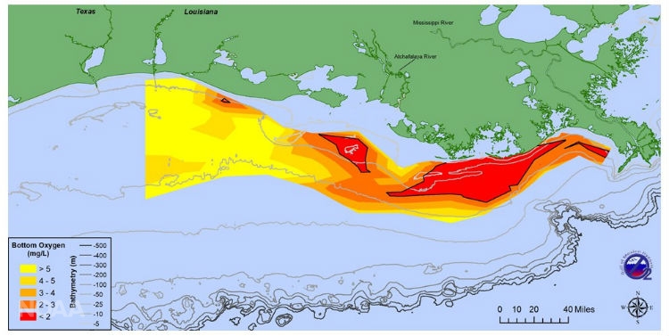
Photo courtesy of NOAA and EPA.
The Upper Iowa River (UIR) contributed approximately 17 kg of nitrogen per watershed hectare (15.2 lbs per acre) annually from 1999 – 2016 to the Mississippi River, according to this study, by IIHR. The study quantifies nutrient loads leaving Iowa through the major rivers. If we correlate these findings to the value or cost of nitrogen fertilizer in 2018, we can calculate the equivalent cost or value of the nitrogen as fertilizer, which would have been $3.9 million annually. Even though the quantity of nutrients in the UIR is less than the nutrient loads calculated for other Iowa rivers, nutrient transport is still a considerable issue, particularly given the potential economic loss associated with the nutrient loss. Improved soil health and in-field nutrient management, as well as urban conservation, could reduce the nutrient loss and thus the economic loss. Explore the Iowa IQWIS app to learn about current nutrient loading in the Upper Iowa River.
The close connection between surface and ground waters in the UIR Watershed, as described here, also makes the nutrient loading of surface waters significant, more so than many other watersheds in Iowa.
The nutrient study by IIHR discusses the connection between higher rates of nutrient transport in relation to confined animal feeding operations. It notes that waste produced by hogs, cattle and other livestock in confined animal feeding operations (CAFOs) must be accounted for as a part of a manure management plan. Liquid manure is generally applied as fertilizer to fields in close proximity to the CAFO location prior to corn planting. According to Iowa State University Extension, one hog produces 1.2 gallons of manure per day for 350 operating days. In the last ten years, there was an increase in 126,094 pigs in the UIR Watershed resulting in an additional 52,959,480 gallons of hog manure, which would require an additional 12,664 acres of land to meet permitted application rates.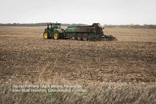
Utilizing ISU Extension calculation factors, the current hog population of the UIR Watershed produces an estimated 111,578,460 gallons of liquid manure annually, requiring 26,681 acres or nearly 10% of all the row crop acres in the UIR Watershed, if applied at the highest acceptable permitted application rate of 4,182 gallons per acre. If these acres in the UIR Watershed receive these quantities of liquid manure, they would be unlikely to need additional commercial fertilizer. Some subwatershed projects in the UIR Watershed have successfully helped producers understand soil fertility and nutrient management to reduce nutrient loss into surface waters. See Staff Beaver Creek Subwatershed Project in Howard County, which was one of the first watershed projects in the state to result in a decrease in nutrient loading in surface waters and could be a model for future subwatershed projects to reduce nonpoint source pollution through voluntary methods.
3.4.2
Point Source Pollution
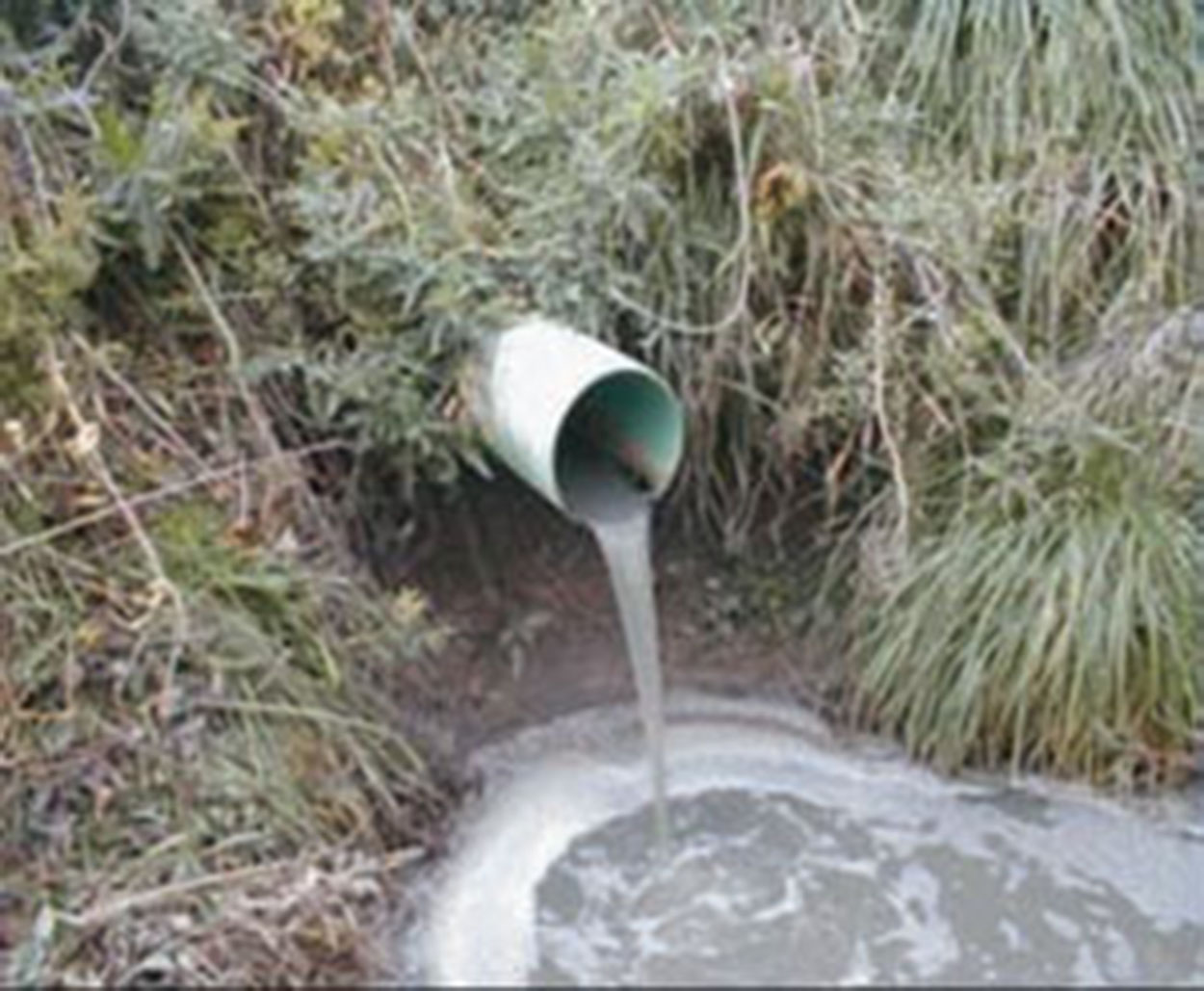
Point source pollution is defined by the EPA as “any single identifiable source of pollution from which pollutants are discharged, such as a pipe, ditch.” Point source pollution is generally associated with cities or industrial complexes.
3.4.3
Community Wastewater Treatment
The incorporated cities in the UIR Watershed all provide wastewater treatment. They each have slightly different wastewater treatment facilities depending on the amount of flow needed to treat the quantity of discharge from their jurisdiction. The largest community, Decorah, uses a wastewater treatment facility that is designed to treat an average wet weather flow of 4.92 million gallons per day, and a peak hourly wet weather flow of 6.9 million gallons per day. (Winneshiek County Hazard Mitigation Plan, 2015) Other communities use lagoons, containment, lift and other treatment methods. These communities provide both on-site and off-site water testing to ensure they are within compliance with DNR water quality standards for water leaving their treatment facility. Water from these facilities empties into a nearby stream or the UIR. Some of the UIR Watershed communities operate on equipment that is very old and in need of an update to ensure that their system functions safely and efficiently in the future. Equipment that isn’t functioning correctly can have a detrimental effect on the water quality and overall health of the UIR Watershed.
3.4.4
Designated Uses and Impaired Surface Waters
The Iowa DNR designates the appropriate use of Iowa’s water bodies, including for lakes, streams and rivers. A water body may be designated for human contact, aquatic life, for drinking water, or for any combination of the three. A waterbody is impaired when its water quality does not fully support one or more of its designated uses. Every two years, the Water Quality Monitoring and Assessment Section of the Iowa DNR compiles an “impaired water list”, or “303(d) list” that identifies the lakes, wetlands, streams, rivers, and portions of rivers that do not meet the water quality standards that have been established for their use. Streams, rivers and lakes can fail to meet their water quality standards for many reasons. They may be impaired by point sources and/or nonpoint sources of pollution, an individual or multiple pollutants, a specific cause or unknown sources. Iowa is required by the federal government to establish a priority ranking for the waters listed as impaired and the ranking considers the severity of pollution and the designated uses of the water body. The Upper Iowa River Watershed contains approximately 300 miles of impaired stream and river segments listed between 2004 to 2016. Water quality is very important for the overall resiliency of the watershed.
Additional information about Iowa’s Section 303(d) Impaired Waters Listings is available here.
Additional information about other types of stream and river designations for surface waters in the UIR Watershed can be found here.
