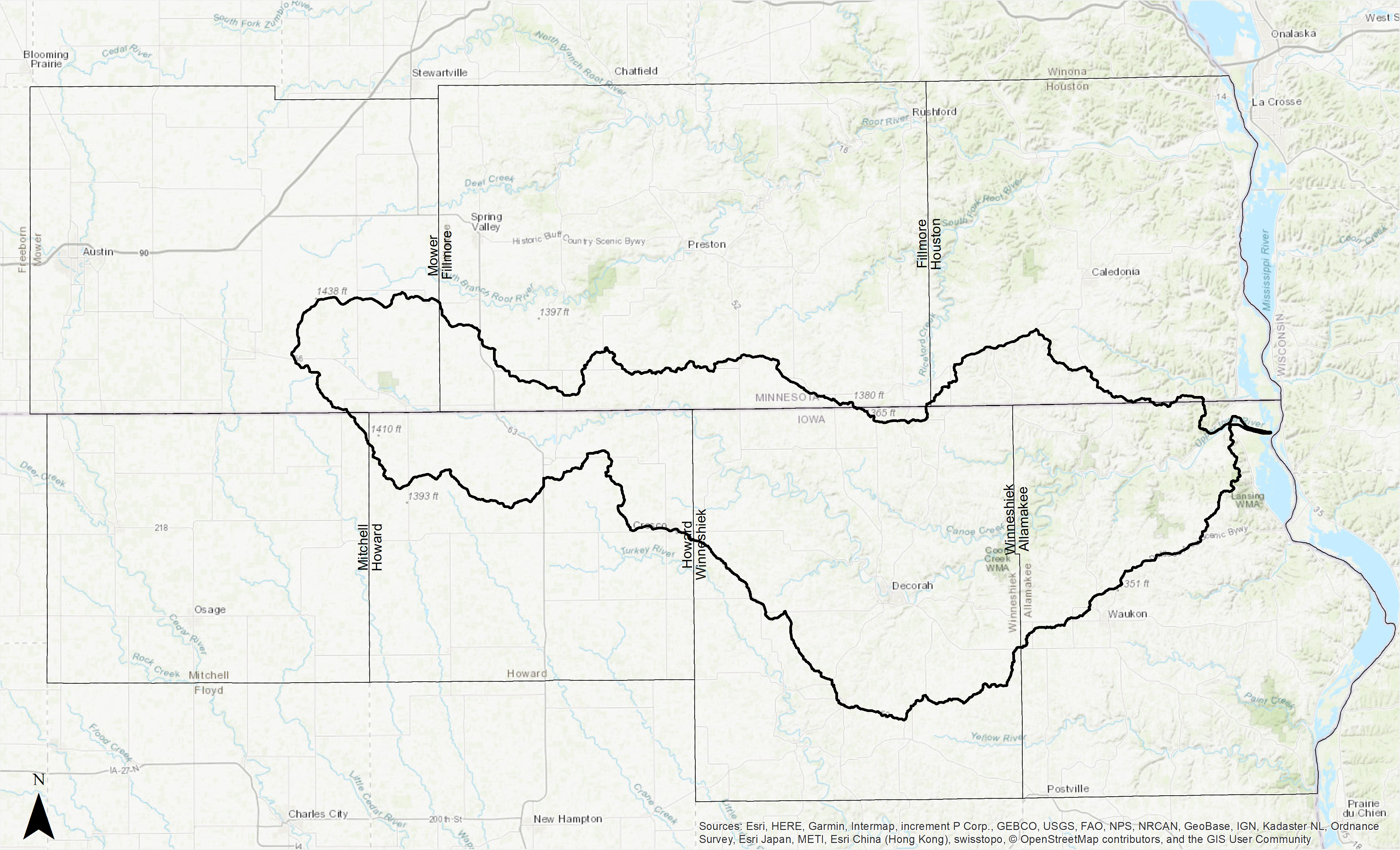
Each of the Upper Iowa River Watershed counties, as well as the watershed residents within each county, face different watershed and conservation challenges associated with 1) the percentage and landscape position of the watershed within their county, 2) the percentage of the county encompassed by the watershed, 3) the number of total acres in the watershed.
Counties with small upland areas of the watershed, such as those in Minnesota and Mitchell County in Iowa, don’t have to deal with the flooding associated with the UIR but their land use and conservation decisions greatly impact downstream counties and producers. Counties with small percentages of the watershed also have lower percentages of their county encompassed by the watershed and a fewer number of producers within the watershed boundary. Unfortunately for those landowners, and everyone downstream of them, targeted state and federal watershed grants and programs for Soil and Water Conservation District (SWCD) projects to help producers implement conservation have traditionally prioritized higher profile HUC 12 watersheds within a county that drain into larger rivers. As a result, the producers in the counties with small percentages of the UIR Watershed had fewer conservation program incentives than producers in their county who live in other higher profile areas.
In the three UIR Watershed Minnesota counties, technical assistance and financial incentives have primarily been targeted to the producers in the Root River or Cedar River watersheds. In Mitchell County, the producers in the Cedar River Watershed have been prioritized. Fortunately watershed planners in Minnesota have recently changed the way they think about the UIR Watershed and begun including it in planning for the Root River Watershed. Downstream counties will benefit from this change in planning if implementation follows.
| County | Acres | % of UIRW | % of County in UIRW |
|---|---|---|---|
| Winneshiek, IA | 279,661.5 | 43.6% | 63.5% |
| Allamakee, IA | 130,838.0 | 20.4% | 30.7% |
| Howard, IA | 90,360.0 | 14.1% | 29.8% |
| Fillmore, MN | 59,228.0 | 9.2% | 10.8% |
| Mower, MN | 51,061.4 | 8.0% | 11.1% |
| Houston, MN | 28,799.5 | 4.5% | 7.9% |
| Mitchell, IA | 952.6 | 0.1% | 0.32% |
Winneshiek County in Iowa, which makes up the largest percentage of the UIR Watershed and has a large percentage of the county’s land area in the UIR Watershed, faces different challenges. Their Soil and Water Conservation District has been forced to identify ways to targeted limited technical and financial assistance to one of several HUC 12 subwatersheds within the larger UIR Watershed. Improving water quality, reducing flooding and improving resiliency in a large river system like the UIR Watershed when technical and financial assistance is focus on one or two smaller subwatersheds is daunting, especially when the karst systems in that subwatershed could be influencing water movement to and from land areas in other subwatersheds. Howard and Allamakee counties and their producers face their own challenges. Those counties are encompassed by multiple watersheds, with just under a third of their counties in the UIR Watershed. In order to serve all the producers in their counties SWCDs must shift their limited technical and financial assistance to subwatersheds in different HUC 8 watersheds. This can mean that producers wait years for a chance to implement conservation practices or even hear from a conservation professional.


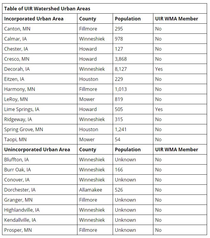
Approximately 27,000 people reside in the Upper Iowa River Watershed with approximately 23,000 of those living in the Iowa portion of the watershed. Over half of the population is living within incorporated or unincorporated communities. The largest community in the watershed is the City of Decorah, population 8,127. Although the Upper Iowa River Watershed is still a relatively rural watershed, communities do impact flooding and water quality. A 2018 study conducted by Zhang, Villarini, Vecchi and Smith published in Nature found that an increase in impervious surfaces can increase total rainfall, shift the location of maximum rainfall, and increase the changes of extreme flooding. Find more information here.
The Upper Iowa River Hydrologic Assessment recognizes the impact that shifts in land use from agricultural uses to urban uses can have on hydrology, runoff and flood magnitude noting the following.
“The transition from agricultural to urban land uses has a profound impact on local hydrology, increasing the amount of runoff, the speed at which water moves through the landscape, and the magnitude of flood peaks. The factors that contribute to these increases (Meierdiercks et al., 2010) are the increase in the percentage of impervious areas within the drainage catchment and its location (Mejia et al., 2010), and the more efficient drainage of the landscape associated with the constructed drainage system — the surface, pipe, and roadway channels that add to the natural stream drainage system. Although traditional stormwater management practices aim to reduce increased flood peaks, urban areas have long periods of high flows that can erode stream channels and degrade aquatic habitat.”
The Table of UIR Watershed Urban Areas provides information about the urban areas in the Upper Iowa River Watershed. It details their name, county, approximate population (2010 Census) and participation/lack of participation in the Upper Iowa River WMA. Please note that only incorporated communities in Iowa were allowed and invited to participate in the Upper Iowa River WMA.
