What is a Subwatershed?
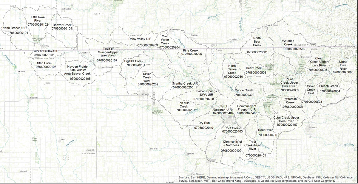
The 640,000 Acre Upper Iowa River (UIR) Watershed can be subdivided into subwatersheds with each individual subwatershed representing either an area of land that flows to a stream that is a tributary of the UIR or an area of land directly adjacent to and draining directly into the UIR. The US Geological Survey (USGS) has officially delineated 34 subwatersheds, which they describe as being “nested” in the UIR Watershed. The UIR subwatersheds range in size, with the smallest encompassing 9,353 acres and the largest encompassing 30,610 acres. USGS provides maps for every hydrologic unit in the United States, including for the UIR Watershed and all its subwatersheds here.
Each hydrologic units has a numbered code that identifies its location in relation to larger watersheds. These hydrologic unit codes are commonly referred to as HUCs. The HUC for the Upper Mississippi River Watershed is 07, for the portion of the Upper Mississippi River Watershed that include the UIR is 0706, and for the UIR Watershed, which is a subwatershed of the Upper Mississippi River Watershed is 07060002. The HUC for Bigalk Creek, which is a subwatershed of the UIR Watershed, is 070600020201.
Upper Iowa Subwatershed Projects and Research
Subwatersheds of the UIR have traditionally been considered the most “manageable” land areas for watershed planning and project implementation. The Iowa DNR 319 Program, the Iowa Department of Agriculture and Land Stewardship (IDALS) Bureaus, USDA Natural Resource Conservation Service (NRCS), and other state and federal entities, have historically awarded grants for watershed planning, technical assistance, and landowner cost share, to county Soil and Water Conservation Districts (SWCDs) and other local conservation entities who conduct outreach to and then work with landowners in subwatersheds of the UIR Watershed. Until the last few years, the majority of watershed funding, but not all, has been tied to water quality and habitat considerations. With the approval of the Iowa Watersheds Approach Project, flood prevention, watershed resiliency, at-risk population vulnerability and other factors became more important in the granting process.
Determining exactly which subwatersheds would be targeted for funding and technical assistance has been accomplished over the years using different methods and analyses, depending on the tools and evaluation techniques and/or research that was available at the time the project was conceived and proposed, depending on state and federal funding requirements, and depending on the capacity of the local partners. In recent years, advances in technology, remote sensing tools, information and data collection and management, modeling, and local-state partnerships have increased the understanding of watershed dynamics, hydrology, land use, water quality, resiliency and other important factors.
This increased understanding of watershed function has impacted subwatershed and watershed planning and project implementation. For example, local, state and federal entities have completed several studies that have helped conservation professionals and watershed residents better understand the impact karst geology has on surface and groundwater movement in the UIR Watershed. See studies by Iowa Geological Survey Bureau, Coldwater Cave Study, York Blind Valley Study MN. These studies confirmed that groundwater basins in the UIR Watershed do not always align with surface water basins and therefore surface water not only intermingles with ground water in the UIR Watershed but moves between subwatersheds. Storm runoff and surface water drop below ground in losing streams, sinkholes and through the porous and fractured bedrock. Once below ground, they quickly move through underground caverns and bedrock fissures to reemerge in different subwatersheds, or even different large watersheds, via springs, wells, and seeps.
An increased understanding of the karst systems of the UIR Watershed has helped conservation professionals better understand the importance of looking at the UIR Watershed and its subwatersheds as a complex system. Although additional dye tracing studies would help watershed residents and conservation professionals better understand exactly where and how losing streams and other karst features transfer water between surficial basins and underground from one stream to another, conservation professionals at least know that surface water does move between subwatersheds. As a result, some SWCD subwatershed projects have targeted multiple subwatersheds, such as the project that was implemented by Winneshiek County SWCD in both Coldwater and Pine subwatersheds. Future dye tracing studies may also help watershed residents and professionals maximize limited funding and technical assistance to more effectively improve water quality and reduce flooding in specific streams and rivers.
In 2018, local, state and federal partners completed, GIS analysis and water quality analysis. They held public meetings, conducted landowner surveys and other research that helped conservation professionals determine where funding could be best invested to have the maximum impact. Important GIS analysis was completed by several different entities for the UIR Watershed. Northeast Iowa RC&D completed a cover crop analysis as well as an infrastructure analysis. Two complementary GIS analyses were completed. The first was a Best Management Practice Analysis completed by Iowa State University and the second was an Agricultultural Conservation Planning Framework analysis conducted by the Iowa Flood Center/IIHF. A short summary of the most extensive GIS analyses completed by partners for the UIR Watershed can be found here. GIS was also utilized by Northeast Iowa RC&D to identify and locate watershed characteristics. The findings are detailed in the Watershed Characteristics and other sections of this UIR Watershed Resiliency Plan.
Past watershed planning, technical assistance and private lands conservation cost share funding in the UIR Watershed and within specific subwatersheds are detailed in the story map below, A Story Map: Upper Iowa Subwatersheds. You may locate your farm, property or community and determine which subwatershed or subwatersheds it lies within by zooming in on the first map. Once you identify your subwatershed, and are interested in knowing more about your subwatershed or what projects have been implemented in your subwatershed, you may select your subwatershed by clicking on the appropriate “tab” found along the top of the Story Map or among the list below.
Existing Best Management Practices (BMPs) in the Upper Iowa River Watershed
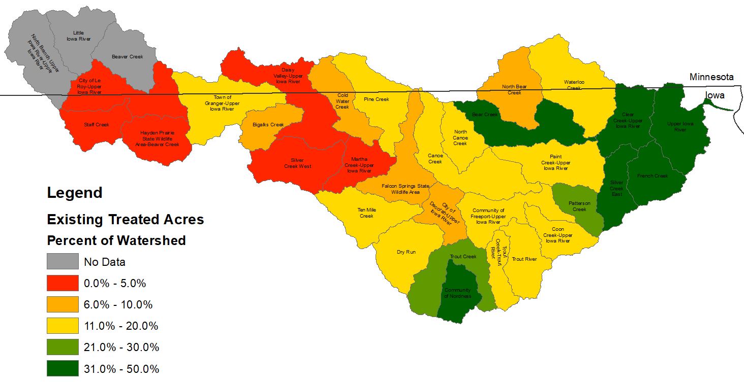
The Iowa Best Management Practice (BMP) Mapping Project completed by Iowa State University (ISU) mapped existing BMPs like grass waterways, contour buffer strips, ponds, Water and Sediment Control Basins (WASCOBS), and terraces. The map on the right shows the percent of each subwatershed that is treated by ponds, WASCOBs, contour buffer strips and grass waterways. Subwatersheds in green, many located in the eastern portion of the Upper Iowa River Watershed, contain retention structures, contour buffer strips or grass waterways that treat over 30% of acres in each subwatershed. Subwatersheds in the Western portion of the Upper Iowa River Watershed contain less then 5% of their acres treated by retention structures, contour buffer strips, or grass waterways. Results from the Iowa BMP Mapping Project directly correlate with previous landowner participation in the Upper Iowa River Watershed. Many of these practices were implemented because of voluntary landowner participation in Upper Iowa River subwatershed projects led by County Soil and Water Conservation Districts (SWCDs), and because of conservation programs available from USDA and implementation by USDA NRCS. Some producers implement conservation programs to protect their soil and water; other producers because they are required to implement conservation practices to keep their soil erosion below a recommended level if they want to participate in Farm Service Agency programs.
Agricultural Conservation Planning Framework Tool: Mapping Potential BMPs in the Upper Iowa River Watershed
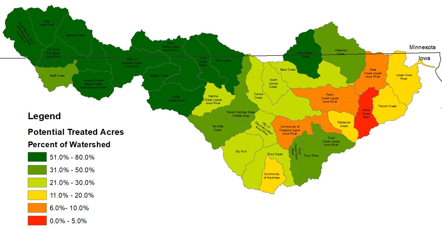
The Agricultural Conservation Planning Framework Tool (ACPF) was used to complete an analyses of potential BMPs in the UIR Watershed by the Iowa Flood Center/IIHR. Although it does not account for the constraints on conservation practice implementation created by karst features, the ACPF tool does helps conservation professionals understand where BMPs, including ponds, WASCOBs, contour buffer strips, grass waterways, and bioreactors, could be placed on the landscape to have the greatest reductions in stream and river flow. The map on the right shows the percent of potential treated acres in each subwatershed. Subwatersheds in green have the most potential locations for implementation of water retention structures like ponds and WASCOBs. Subwatersheds with the highest potential are located in the western half of the Upper Iowa River Watershed where the greatest flow reductions can be achieved according to the UIR Hydrologic Assessment.
When comparing results from the Iowa BMP Mapping Project and the ACPF tool, the greatest landowner participation has occurred in the eastern half of the UIR Watershed where implementation of retention structures has the lowest effect on flood reduction. Landowner participation was lower in the western half of the UIR Watershed where ACPF results showed the highest potential for implementation of flood reduction practices that have the greatest affect on flood reduction. ACPF results and the Iowa BMP Mapping Project can be used by County SWCDs, Counties, Cities, and landowners to target future subwatershed projects, and to see potential locations for implementation of flood reduction practices on their land.
5.5
A Story Map: Upper Iowa Subwatersheds


